Water doesn't wander. It follows a deterministic path set by topography, gravity, and the geometry of river networks — and it has been doing so without interruption since long before anyone thought to watch. What is new is the ability to watch.
Try River Runner
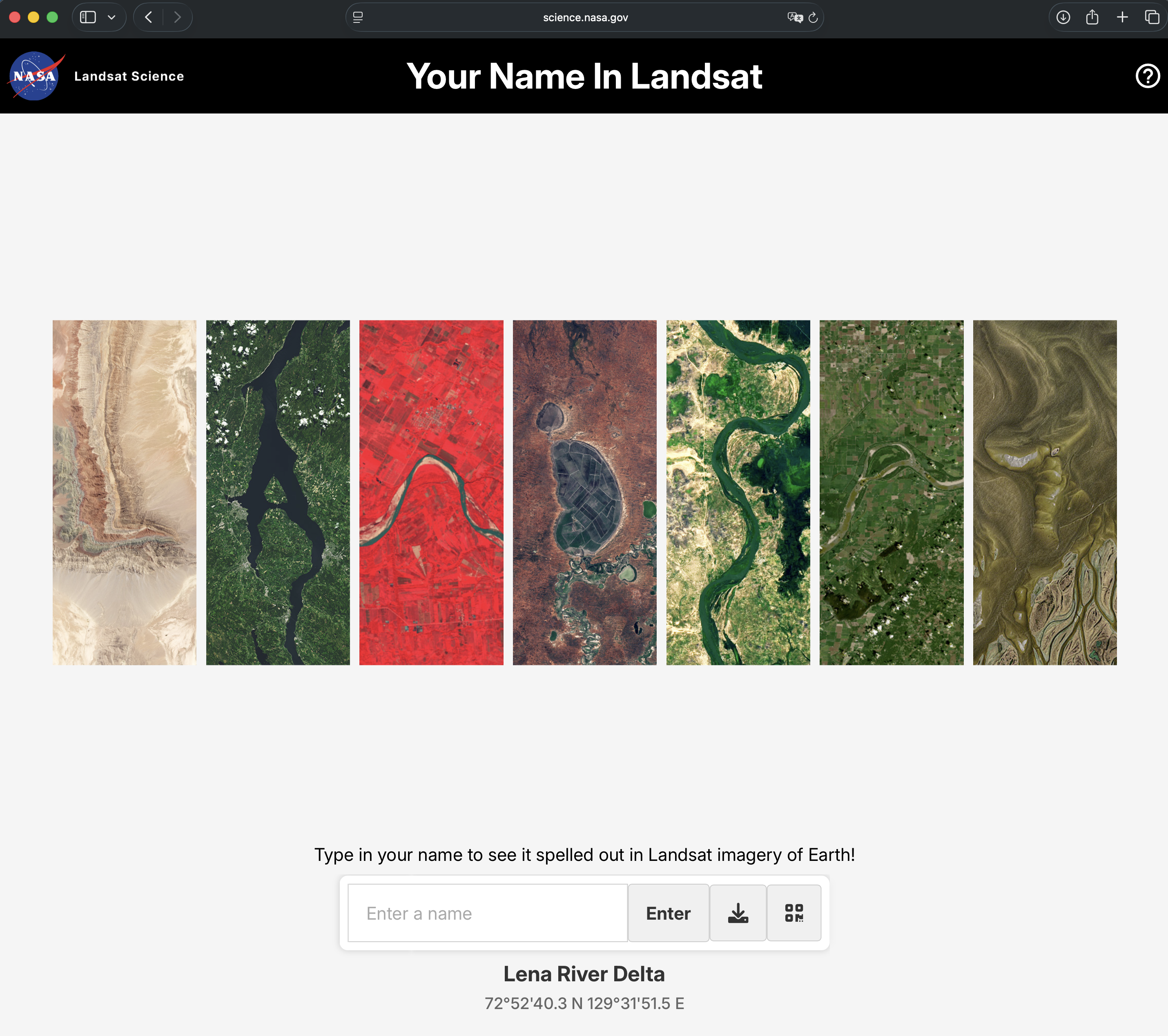
River Runner, built by data analyst Sam Learner, lets you click anywhere on a map and trace the exact downstream journey of a raindrop landing at that point — from the moment it hits the ground to wherever water eventually takes it. It sounds like a small trick. It is not a small trick.
River Runner — Sam Learner
Click anywhere in the world. Watch where water goes.
Built by
Sam Learner
Data
USGS NHDPlus
Coverage
Global
Type
Interactive
Year
2021–2022
The Unlikely Starting Point
Learner's initial prompt was not hydrological. He was thinking about the Rocky Mountains — specifically, about the Continental Divide, and what it means that a ridge of high ground runs down the spine of North America splitting the continent's drainage in two. Rain falling a few feet to the east of the divide eventually reaches the Atlantic; a few feet to the west, the Pacific.
Living in Pittsburgh, at the point where the Allegheny and Monongahela rivers join to form the Ohio, he was already standing at one answer. The Ohio flows to the Mississippi; the Mississippi flows to the Gulf of Mexico. The visualization started as a simple trace of the continental divide's drainage and became, through iteration, a tool that works for any point on Earth.
“You probably live upstream from a lot of other people.”
— Sam Learner
What the Data Actually Is
The U.S. version runs on USGS NHDPlus data — the National Hydrography Dataset Plus, a comprehensive digital model of the country's waterways. Every named and unnamed stream, every river flowline, every connection between them is encoded in this dataset. The USGS's NLDI API handles the routing: given a coordinate, it finds the nearest flowline and traces the downstream path through the network.
For the global version, released in early 2022, this infrastructure did not exist in usable form. Learner worked with the USGS water team and the Internet of Water to build it. The global back-end required constructing routing logic from scratch. The tool renders paths using Mapbox with 3D elevation data, which is what makes it feel less like reading a map and more like riding the current. The determinism of water — the way a single point on the map commits irrevocably to a single path — is the same quality that makes a well-constructed diagram more honest than a paragraph.
Some Distances
The numbers matter. They make concrete what watershed connectivity means in practice.
Hiland, Wyoming
3,400 miles
Powder River → Bighorn → Yellowstone → Missouri → Mississippi → Gulf of Mexico. Thirteen states. A raindrop on a Wyoming hillside takes the long way to the sea.
Custer, South Dakota
2,600+ miles
Downstream through the Cheyenne River basin to the Missouri and the Mississippi. The Great Plains drain a vast, slow-moving territory.
Chengdu, China
~2,000 miles
The Yangtze basin carries Sichuan rainfall to the East China Sea. One of the world's great river systems, visible in a single click.
Cochabamba, Bolivia
3,000+ miles
Into the Amazon system and across the continent to the Atlantic. South America's drainage basin is the largest on Earth by discharge.
Tercan, Turkey
2,867 km
The source of the Euphrates. Water from the eastern Anatolian plateau feeds the Fırat, passes through two countries' worth of dams and reservoirs, and reaches the Persian Gulf as the Shatt al-Arab.
The Upstream Problem
The map's usefulness runs in both directions. Following water downstream shows you where a raindrop ends up. Following it upstream shows you who sent it. The same back-end data could power a complementary tool — a map that shows everyone upstream of a given point, which is to say, everyone whose land use and waste disposal eventually affects you.
This is not an abstract concern. Fertilizer applied to fields in Minnesota and Montana enters the Missouri-Mississippi system and ends up in the Gulf of Mexico, where excess nitrogen feeds algal blooms that deplete oxygen and kill marine life — a dead zone that has persisted for decades. Plastic pellets discharged near factories in Central Europe can wash into the Danube and reach the Black Sea. A poorly lined landfill in one watershed can contaminate drinking water several states away. The map does not say any of this directly. It shows you the path, and the path says it. That quiet indirection is reminiscent of how the best teaching works — you arrive at the conclusion yourself, which is why it sticks.
“What we put in a river or stream ends up in someone else's water.”
— Sam Learner
What Makes It Work
River Runner is not the first watershed visualization, and it is not the most technically sophisticated. What it does differently is collapse the distance between curiosity and answer. You wonder about your backyard. You click. You watch. The question resolves in about thirty seconds and immediately generates three more questions: What about my parents' house? What about that mountain I hiked last summer? What about the river I can see from this window?
Learner spent weeks iterating on navigation smoothness specifically because a sluggish transition from click to animation breaks the spell. The 3D flythrough is not decorative — it gives spatial intuition to something that is otherwise just a list of river names and distances. You understand in your body that the water is going downhill, that it is covering real terrain, that the journey is long. There is also something precise about the question itself: not the basin, but this drop, from here, going there. The specificity is what lands — the same way that a puzzle with exactly one solution feels different from one with many.