Walk the International Space Station on Google Street View
Google Street View · ISS · Free
Street View started on a street. That was the whole point — walk a city block from your desk, check the parking situation before you drive, see what a neighborhood actually looks like before you rent an apartment. It was a useful, grounded, deeply terrestrial tool. Then Google sent it to the Moon. Then Mars. And now, in a move that redefines what “street” means entirely, to the International Space Station — an object moving at 27,600 kilometers per hour in low Earth orbit, with no street, no address, and no fixed location on any map.
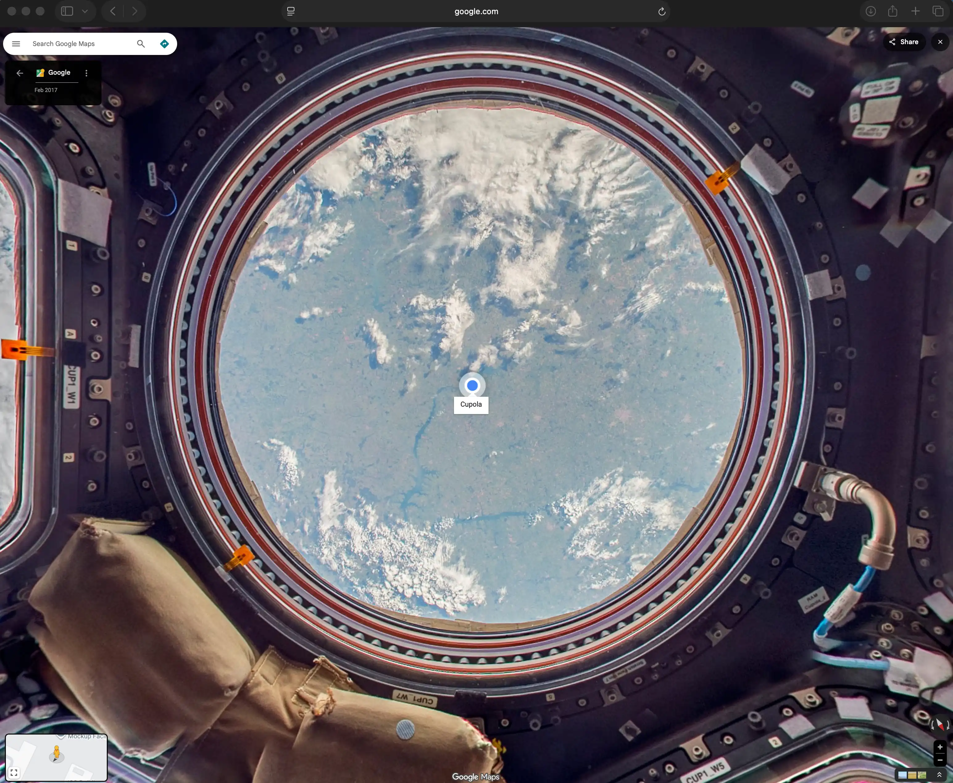
The imagery was captured by Thomas Pesquet, a flight engineer at the European Space Agency who spent six months aboard the ISS. Pesquet brought a Street View camera to the station and documented the interior — the modules, the corridors, the labs, the cupola with its view of Earth below. The result is a collection of 360° panoramas that you can navigate the same way you would navigate any Street View location, except that through the windows, instead of buildings or sky, you can see the curve of the planet. If NASA's Landsat tool lets you see Earth as a pattern of colors from above, this lets you look at Earth from inside a spacecraft while it orbits.
“Now you can explore the inside of the ISS from the comfort of your own home.”
Thomas Pesquet, ESA · Google Blog, 2017
There is a technical problem embedded in this project that is easy to overlook. Street View works by pinning imagery to a specific location on Earth. The ISS orbits the planet once every 90 minutes. It has no address. Google's solution is elegant in its pragmatism: the Street View is officially located at Building 9 of the Lyndon B. Johnson Space Center in Houston, Texas — a facility that contains full-scale physical mockups of every pressurized module on the actual station. The ISS exists in orbit; its Street View twin exists in Houston. You are, technically, visiting both at once.
What You Can See
The Street View covers the interior of the station's pressurized modules: the US Orbital Segment including Node 1 (Unity), Node 2 (Harmony), and Node 3 (Tranquility); the laboratory modules including Destiny and Columbus; and the cupola — the seven-windowed observation module from which the most famous photographs of Earth from the station are taken.
The imagery also includes annotations — labels identifying equipment, explaining systems, providing context for what you're looking at. This was, at the time of release, the first use of annotations in Street View anywhere. The feature arrived in Street View before it arrived in Google Earth.
This is not the first time Street View has left Earth. The Moon and Mars have had Street View imagery for years — Google Maps routes you to the surface of Mars if you navigate far enough from the familiar blue marble. But the ISS is different from either of those locations in one important way: people live there. At any given moment, between three and seven human beings are aboard the station, conducting experiments, maintaining systems, and looking out the cupola windows at a planet they will return to in a few months. Benjamin Grant's Overview collects the satellite images of Earth that make the planet abstract and geometrical. The ISS Street View inverts that: you are inside the machine that takes those photographs, looking out.
Google Street View · International Space Station
420 km above Earth.
Available on your browser.
Thomas Pesquet · ESA · Orbit
Explore the ISS →There is something worth sitting with in the experience of using this tool. You are navigating, with a mouse or a finger, through the same corridors that astronauts navigate in microgravity. The handrails you see on every surface are there because there is no up or down. The equipment is strapped to the walls because it would otherwise float away. Everything in the frame is there for a reason that has been carefully engineered, and you can look at it as long as you want, from your desk, for free.